Kayak Greene County
  • Home
  • WATER CONDITIONS
  • Launch Points
  • Trip Ideas
  • Tips
  • Blog
WATER & WEATHER CONDITIONS

TENMILE CREEK & DUNKARD CREEK WATER LEVELS
  • ABOVE 200 cpfs to be passable. With lower levels you may need to walk your kayak in some sections.
  • UNDER 600 cpfs for beginners to pass safely.
  • ABOVE 600 cpfs with experienced kayakers.

Charts are currently not working. We hope to have a solution soon.

South Fork Tenmile Creek

Station ID: 03072000 | Waynesburg, PA

□ Upstream Live Indicator: Jefferson Station 03073000 does not transmit real-time telemetry. Use this active upstream Waynesburg chart to review recent water flow trends before paddling.

Tap the link below to open the official, real-time 7-day flow graph. Review the water velocity and discharge trends directly on your phone.

Launch Live Flow Graph ↗

Dunkard Creek at Shannopin

Station ID: 03072500 | Shannopin, PA

□ Real-Time Telemetry: Continuous data transmission is fully active. This chart displays water discharge speeds measured in cubic feet per second (cfs).

Tap the link below to load the live-updating USGS streamflow dashboard. Check current volume baselines before arriving at the boat ramp.

Launch Live Flow Graph ↗

Picture
Picture
Picture
Picture
Picture
HOME  :  LAUNCH POINTS  :  TRIP IDEAS  : T IPS  :  RENT KAYAKS  :  BLOG  :  CONTACT  :  HELP US

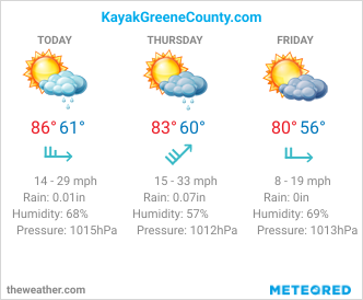
CURRENT WATER LEVEL AND WEATHER CONDITIONS

JOIN OUR FACEBOOK GROUP HERE
​
KayakGreeneCounty.com is hosted by McMillen Photography and maintained by Ben McMillen
Greene County, PA
​Last Update 2025
  • Home
  • WATER CONDITIONS
  • Launch Points
  • Trip Ideas
  • Tips
  • Blog